April 2021
Author: Paul Damron
Maps have fundamentally changed the way people research and scout for hunts. One of the main reasons Huntin’ Fool decided to provide its members with a 3D mapping application was to publish our very own species data.
As most of you know, Huntin’ Fool has proven that we have some of the best data in the industry when it comes to hunting. Our members are a great resource, along with our Hunt Advisors. Collectively, the Hunt Advisors spend countless hours putting all of the data together to publish it in our monthly magazine. Being able to access this data in a map format is huge. Not only does our map give you 3D, Waypoint Management, and Customizable Layers, but it also allows you to filter our hunt data.
Last month, I provided a brief overview of the Hunt Filters, but it's simple. You set up the filters you are looking for, click submit, and just like that, icons on the map appear that match your filter. This month, I wanted to share with you what information you can expect after filtering. We wanted to make sure that we brought the data together that would fit everyone's data needs.
RECORD DISPLAY TYPES:
- Map Icon
- Detailed List
- Unit Details
- Data Table
MAP ICONS
As was mentioned above, once you set a filter, you can view your results across state lines with an icon on the map. These icons are located within the center of each unit/zone/area. If you click on them, you can see more information about that unit.
DETAILED LIST
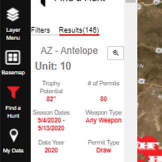
Our Detailed List is located in a tab at the top of the Find a Hunt panel, or once you click submit, a button appears near the Search button called “Results.” This will jump you to our Detailed List of your filtered search results. This list is sorted by species size, so the largest score will appear at the top.
In this list we provide enough information for you to understand the result. Some of the information you will find is:
- Unit Name, Number
- Trophy Potential
- # of Permits
- Season Dates
- Permit Type
- Short Description of the Unit
- Button for Unit Details
UNIT DETAILS
The Unit Details are associated with each result. After you have reviewed the information in the Results panel, you can click on the Unit Details button, which is located at the bottom of each unit result. The Unit Details provide additional detailed information about the specific result. Information you will find on this pop-up window includes:
- State
- Unit Name
- Trophy Potential
- # of Permits
- Season Dates
- Weapon Type
- Data Year
- Permit Type
- Public Land %
- Public Land Access Type
- Non-Res Random # of Permits
- Non-Res Preference # of Permits
- Non-Res Total # of Permits
- HF Comments
DATA TABLE
In my line of work, I have found that not everyone likes one way to display the data. We have been able to integrate an interactive table of all your results. The Data Table is located at the bottom of the Find a Hunt panel next to the Results button. There will be a Table button, and once you click on it, the Data Table will appear full screen over the map. This Data Table is awesome. It's interactive and lets you drill down the data. At the top of the Data Table screen, you will see an arrow. You can click and hold that arrow and drag the Data Table downward to still see the map.
Once you are looking at the Data Table, you will notice that there are column headings and a search box. You can sort Ascending or Descending if you click the column heading. The search box lets you drill through the data. Let's say my initial filter is looking at all the states, but once I have the table up, I can search a specific state. Let's say I want to search Arizona. In the State column's search box, I type AZ. All of Arizona’s results will show up. I can do this on all of the columns or just a few. This Data Table allows you to really filter through the data.
I hope this and last month's articles have helped you understand that data is a big deal to us and that as technology changes, we will do our best to keep up on it. Our data and research sets us apart, and providing it in a map makes it even more so, allowing you to e-scout efficiently.